NAME
r.rgb - Splits a raster map into red, green and blue maps.KEYWORDS
raster, RGB, separate, splitSYNOPSIS
r.rgb
r.rgb --helpr.rgb input=name [red=name] [green=name] [blue=name] [--overwrite] [--help] [--verbose] [--quiet] [--ui]
Flags:
- --overwrite
- Allow output files to overwrite existing files
- --help
- Print usage summary
- --verbose
- Verbose module output
- --quiet
- Quiet module output
- --ui
- Force launching GUI dialog
Parameters:
- input=name [required]
- Name of input raster map
- red=name
- Red channel raster map name
- green=name
- Green channel raster map name
- blue=name
- Blue channel raster map name
Table of contents
DESCRIPTION
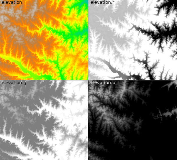
r.rgb generates separate red, green and blue maps from a raster map and its associated color table (grey255).EXAMPLE
g.region raster=elevation -p
r.rgb input=elevation red=elevation.r green=elevation.g blue=elevation.b
In this case r.rgb produces in the current mapset three new raster maps - 'elevation.r', 'elevation.g', 'elevation.b'.
SEE ALSO
r.composite, r.blend, r.colors, r.mapcalcAUTHOR
Glynn ClementsSOURCE CODE
Available at: r.rgb source code (history)
Accessed: Monday Apr 01 03:09:29 2024
Main index | Raster index | Topics index | Keywords index | Graphical index | Full index
© 2003-2024 GRASS Development Team, GRASS GIS 8.3.2 Reference Manual